背景:生态系统健康是指自然生态系统自我组织、自我维持和恢复的能力,是人类生存和发展的基础。随着人类活动的加剧,生态系统健康受到了严重的威胁,需要加强监测和评估。景观格局是影响生态系统健康的最基本和最重要的因素之一,它通过改变生态系统的自然状态和组织结构,影响其生态功能和服务。因此,研究景观格局变化与生态系统健康之间的关系,对于恢复受损和退化的生态系统具有重要意义。山地生态系统为全球一半以上的人口提供了商品和服务,并在保障粮食安全、维持生物多样性和乡村景观等方面发挥了重要作用。山地景观格局受地形因素的影响,具有明显的空间规律性和多样性,同时也对生态系统健康产生了不同的影响。因此,从多维空间角度分析山地景观格局变化对生态系统健康的影响,对于实现山地人地系统的协调发展具有重要意义。
以中国苗岭山区为例,基于地形梯度、景观指标和生态系统健康评价指标,分析了2000年至2020年间景观格局变化和生态系统健康变化的时空特征,并利用秩相关分析探讨了不同地形梯度下景观格局变化与生态系统健康变化之间的关系。该研究旨在揭示山地景观格局变化对生态系统健康的影响机制,并为优化山地景观管理和保护生态系统提供参考依据。
研究成果:Effects of landscape patterns and their changes on ecosystem health under different topographic gradients: A case study of the Miaoling Mountains in southern China
成果作者:李敏,李阳兵,罗光杰,等
成果简介:生态系统健康状况是景观格局生态效应的重要表征,精细分析山区景观格局变化对生态系统健康影响的差异性,对于山区人地系统协同发展具有重要意义。本研究基于景观生态学理论和地形梯度构建了景观格局生态效应的研究框架。以中国苗岭为例,利用空间分析技术,分析了2000年至2020年景观格局的变化过程,并利用秩相关分析法检测了生态系统健康对景观格局变化的响应。结果表明:(1)研究期间研究区景观格局变化显著,尤其是在地理条件差的地区,主要呈现出林地景观规模扩张,农用地景观优势位向缓坡低地地区转移。(2)生态系统处于平均健康水平(mean EHI=0.58),EHI自2000年以来呈现出“V”字型动态特征。(3)景观格局变化对生态系统健康有明显影响,这种影响力在地形梯度上差异显著,景观形状指数(LSI)和香农多样性指数(SHDI)是影响生态系统健康状况的主要因素。本研究强调了在苗岭因地制宜实施区域和系统的景观管理战略的重要性,提出了围绕林地和农用地进行分区管控等策略。研究结果可为苗岭明确重点保护区和控制指标进行区域生态修复,以及为全球山区进行景观管理提供有价值的参考。
成果图表:
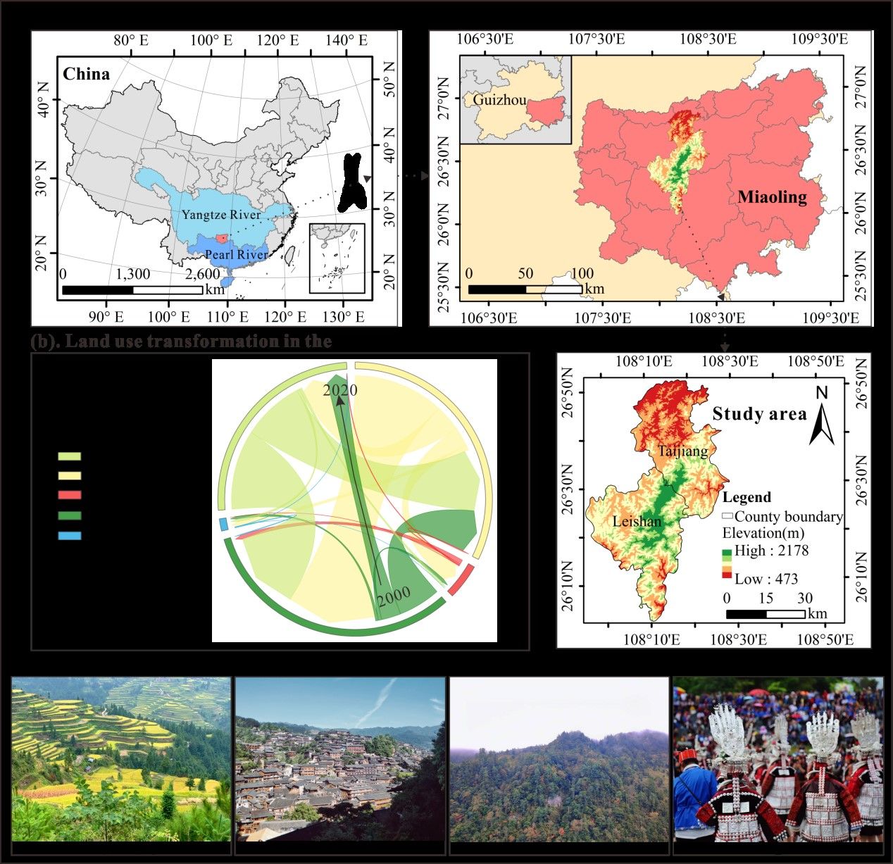
图1 研究区示意图
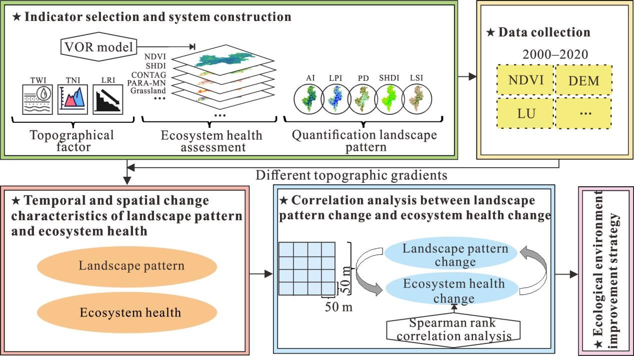
图2 研究框架
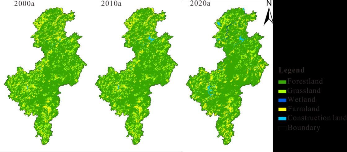
图3 2000-2020年研究区土地利用分布
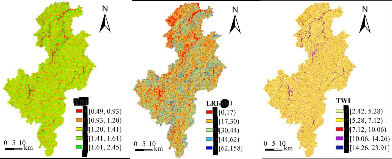
图4 地形指标分级及其空间分布
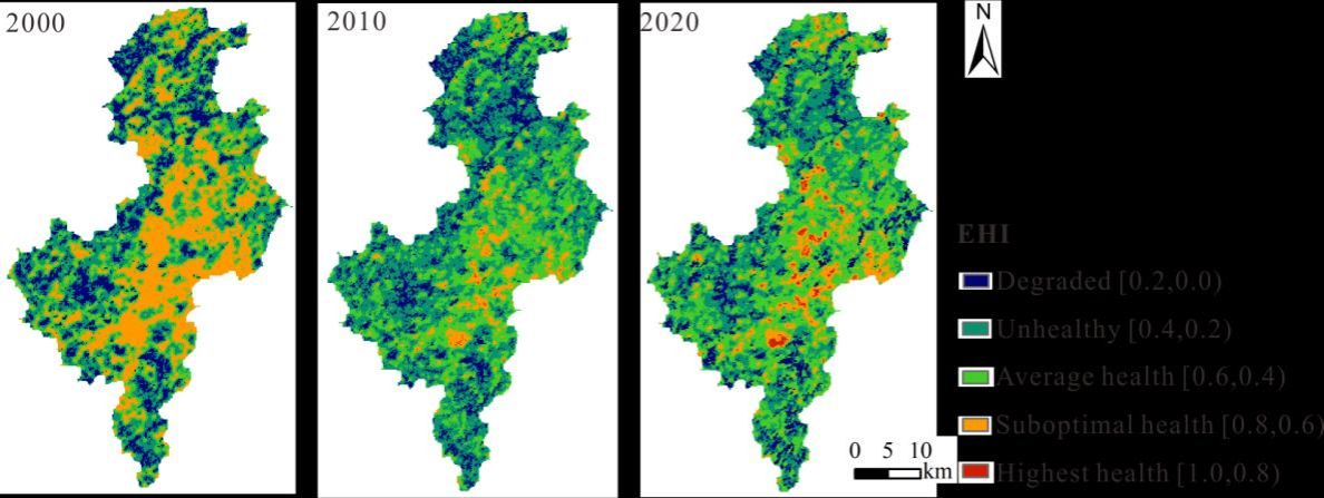
图5 2000-2020年研究区生态系统健康的空间分布
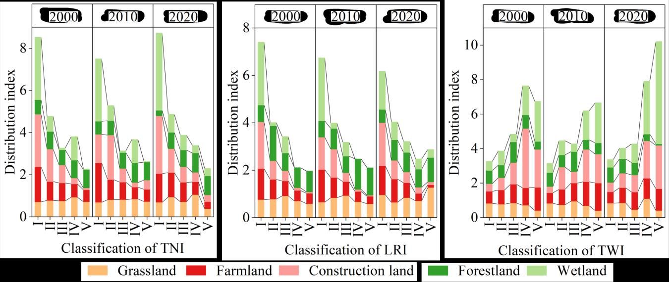
图6 不同地形梯度下景观类型的分布指数
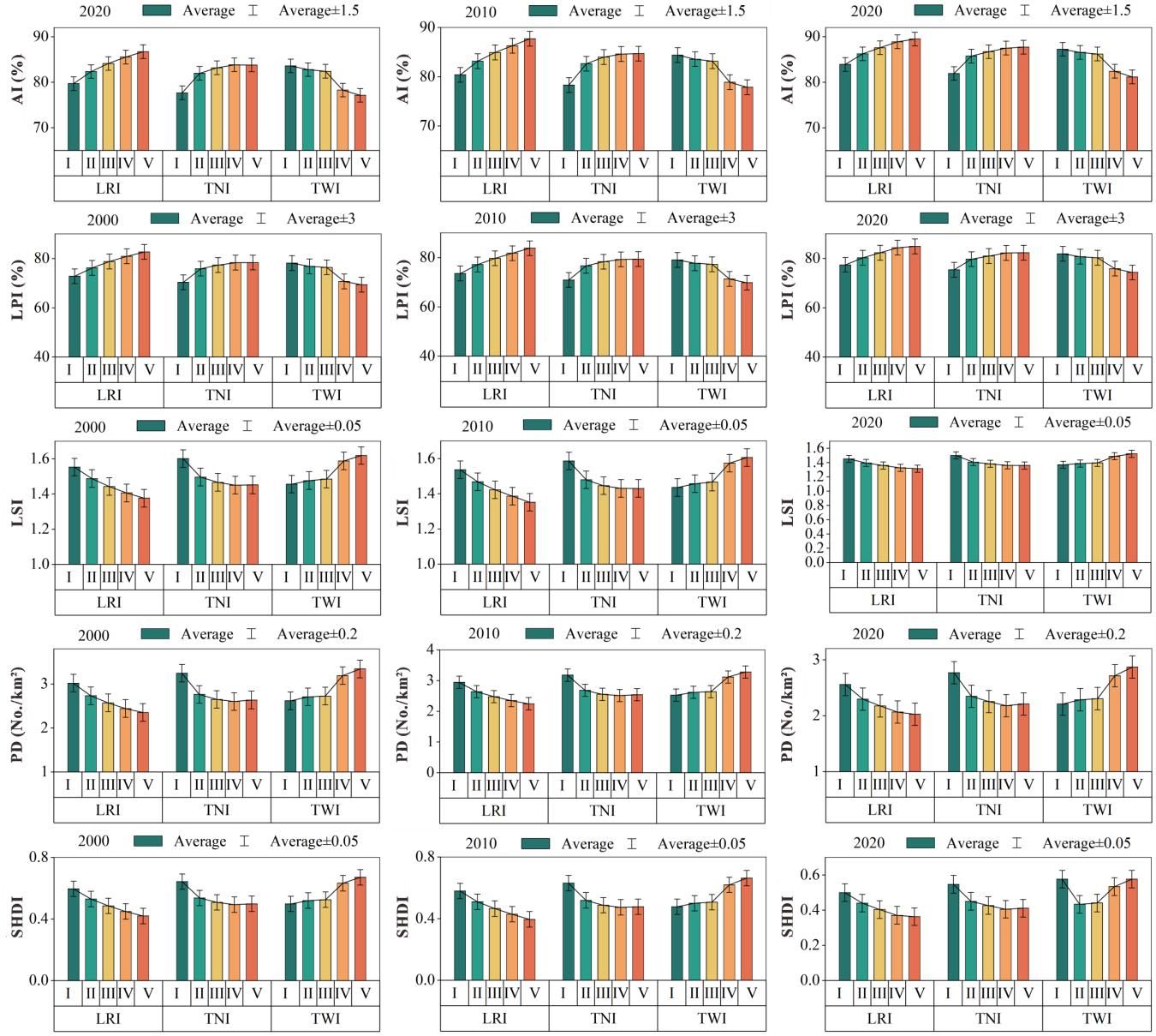
图7 不同地形梯度下的景观指数
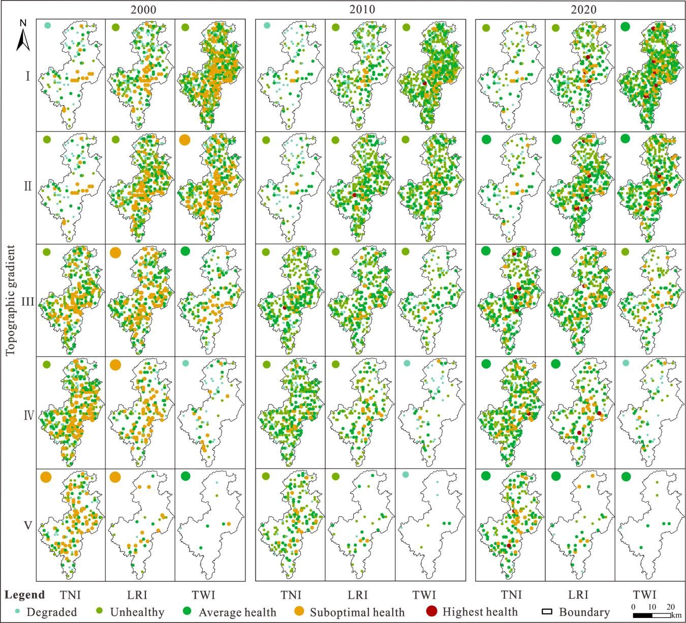
图8 不同地形梯度下的生态系统健康状况
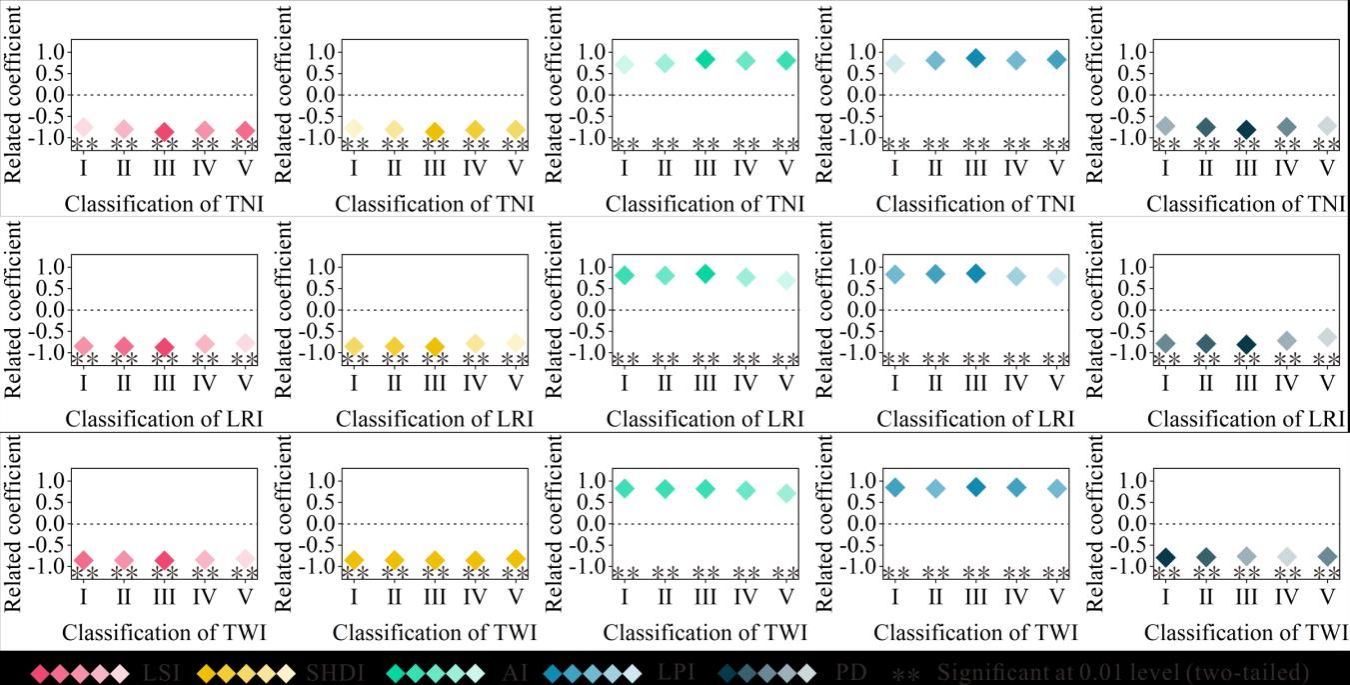
图9 不同地形梯度下景观指数变化值与生态系统健康变化值之间的相关性
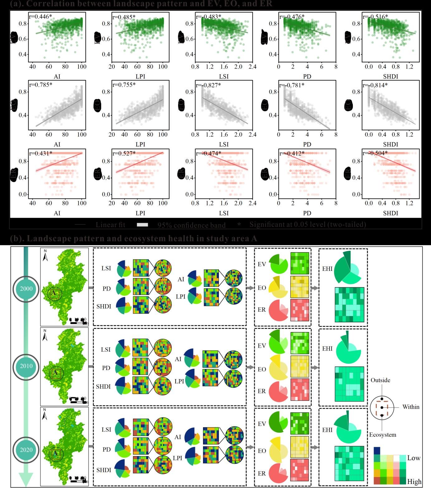
图10 山区景观格局变化对生态系统健康的影响机制
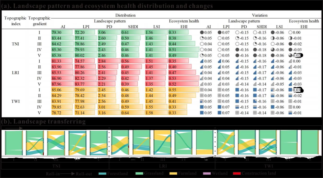
图11 20年间不同地形梯度下的景观格局和生态系统健康的分布与变化及景观类型转移情况
表1 地形因子及其描述
Topographical factor | Formula | Description |
Terrain niche index (TNI)
|

| E and are the elevations of any point (m) and the regional average elevation (m), respectively; S and are the elevations of any point (m) and the regional average elevation (m), respectively; S and are the slopes of any point (°) and the regional average slope (°), respectively. In areas with low elevation and low slope, TNI is small; in areas with high elevation and high slope, TNI is large; in areas with high elevation and low slope or low elevation and high slope and in areas with moderate elevation and slope, TNI is intermediate (Zang et al., 2019). are the slopes of any point (°) and the regional average slope (°), respectively. In areas with low elevation and low slope, TNI is small; in areas with high elevation and high slope, TNI is large; in areas with high elevation and low slope or low elevation and high slope and in areas with moderate elevation and slope, TNI is intermediate (Zang et al., 2019). |
Landform relief index (LRI)
|

| Dmax and Dmin are the maximum elevation (m) and minimum elevation (m) under the 3×3 image element window, respectively. The greater the relative altitude of the elevation, the greater the LRI (Ma et al., 2021). |
Topographic wetness index (TWI)
|

|
 is the confluence area (m2/m) per unit contour length at any flow point through the surface; is the confluence area (m2/m) per unit contour length at any flow point through the surface; is the slope (°) at that point. The higher the TWI in areas with higher sink flows and lower slopes, the more the soil water is prone to saturation and surface runoff (Mhiret et al., 2019). is the slope (°) at that point. The higher the TWI in areas with higher sink flows and lower slopes, the more the soil water is prone to saturation and surface runoff (Mhiret et al., 2019).
|
表2 生态系统组织的判断矩阵
Subsystem level | LF | LC | LS |
LF | 1.00 | 0.25 | 0.14 |
LC | 4.00 | 1.00 | 0.50 |
LS | 7.00 | 2.00 | 1.00 |
Index level | SHDI | PD | AI | CONTAG | DIVISION | PARA-MN | AWMSI |
SHDI | 1.00 | 0.20 | — | — | — | — | — |
PD | 5.00 | 1.00 | — | — | — | — | — |
AI | — | — | 1.00 | 4.00 | 2.00 | — | — |
CONTAG | — | — | 0.25 | 1.00 | 0.33 | — | — |
DIVISION | — | — | 0.50 | 3.00 | 1.00 | — | — |
PARA-MN | — | — | — | — | — | 1.00 | 0.50 |
AWMSI | — | — | — | — | — | 2.00 | 1.00 |
LF, landscape fragmentation; LC, landscape connectivity; LS, landscape shape; SHDI, Shannon diversity index; PD, patch density; AI, aggregation index; CONTAG, contagion index; DIVISION, division index; PARA-MN, perimeter/area ratio-mean; AWMSI, area weighted mean shape index.
表3 不同土地利用类型的生态系统恢复力系数(ERC)
Land use type | Forestland | Grassland | Wetland | Farmland | Construction land |
ERC | 0.6 | 0.8 | 0.7 | 0.3 | 0.2 |
表4 2000-2020年研究区景观格局的定量特征
Year | Forestland (km2) | Grassland (km2) | Wetland (km2) | Farmland (km2) | Construction land (km2) | SHDI | AI (%) | PD (No./km2) | LPI (%) | LSI |
2000 | 1732.03 | 297.62 | 6.08 | 229.3 | 17.74 | 0.76 | 75.82 | 1.03 | 74.71 | 28.06 |
2010 | 1755.73 | 303.53 | 6.08 | 194.46 | 22.96 | 0.74 | 76.84 | 0.97 | 75.79 | 26.97 |
2020 | 1825.00 | 211.26 | 13.79 | 198.49 | 34.23 | 0.70 | 80.33 | 0.75 | 79.60 | 23.22 |
表5 2000-2020年生态系统健康状况的定量特征
Year | Degraded (%) | Unhealthy (%) | Average health (%) | Suboptimal health (%) | Highest health (%) | EHI |
2000 | 15.66 | 28.85 | 28.94 | 26.55 | 0.00 | 0.64 |
2010 | 13.02 | 46.57 | 34.46 | 5.86 | 0.09 | 0.48 |
2020 | 10.32 | 36.39 | 41.84 | 10.18 | 1.26 | 0.61 |
项目资助:国家自然科学基金(42061035 & 41661020)、贵州省重大科技成果转化项目“喀斯特石漠化生态恢复技术集成与示范”([2022]010)。
期刊简介: ECOLOGICAL INDICATORS创刊于2001年。该期刊由Elsevier出版社出版,属于环境科学与生态学领域,2022年影响因子为6.9分,属于中科院SCI二区 Top期刊。该期刊的最终目标是将生态和环境指标的监测和评估与管理实践相结合。研究范围主要涵盖生态系统健康指标、生态系统功能指标、可持续发展指标、生态系统服务指标等。

第一作者简介:李敏(1996—),女,苗族,贵州台江人,中共党员。太阳成集团tyc122cc2021级自然地理学硕士研究生。参与导师多项科研课题,曾获研究生国家奖学金、三好员工等荣誉。主要研究方向为山区景观格局及其生态效应研究。目前在研期间取得代表性研究成果如下:
[1] Li M, Luo G, Li Y, et al. Effects of landscape patterns and their changes on ecosystem health under different topographic gradients: A case study of the Miaoling Mountains in southern China[J]. Ecological Indicators, 2023, 154: 110796. DOI: 10.1016/j.ecolind.2023.110796

导师简介:李阳兵(1968- ),男,重庆潼南人,教授、博士生导师,中国科学院地球化学研究所博士后,中国科学院生态环境中心“西部之光”访问学者。近期主要从事岩溶山地人地关系与景观生态变迁研究。主持国家自然科学基金3项:乡村振兴背景下岩溶山地坡耕地利用转型时空过程与机制(42061035)、岩溶山地乡村坝子土地利用多功能性识别及其时空演化与机理研究—以贵州为例(41661020)、丛洼地区乡村聚落变迁及其生态效应-以贵州为例(41261045),教育部人文社科项目和省基金等10余项,参与承担国家973计划、国家重点研发计划、国家科技惠民计划、国家科技支撑计划重大课题等多项。在科学出版社出版专著4部、合编面向21世纪教材1部;获国家级奖1项、省部级奖3项;荣获“教育部新世纪优秀人才”、“贵州省青年科技奖”,2012年“贵州省优秀科技工作者”等荣誉称号。以第一作者和通讯作者在中外学术刊物发表论文100余篇。

成果链接:本期推送“Effects of landscape patterns and their changes on ecosystem health under different topographic gradients: A case study of the Miaoling Mountains in southern China”文章原文下载:https://www.sciencedirect.com/science/article/pii/S1470160X2300938X
一审(校):谢小兰;二审(校):吴沂晓;三审(校):赵翠薇

